Improving Step-Free Routes on Google Maps
Role
UI Designer
Timeline
August 2023 to June 2024
Project Goal
How can we make Google Maps more accessible and inclusive?
The objective is to enhance the accessibility and inclusivity of Google Maps by optimizing the visibility and usability of step-free route options.
The Challenge
Before starting my project, I decided to look at Google Maps' current iteration and how it conveys step free routes and I noticed the following issues:

In the current iteration of Google Maps, in order for step free routes to be visible, they must be toggled on by going into the “options.”
Having to toggle step-free routes assumes every user is able-bodied.
The current iteration of Google Maps delineates inclines with arrows towards the direction preview at the bottom. The small arrows make it hard for a user to make sense of the incline and decline on a route.

Knowing the incline and decline is important for step-free routes because a wheelchair user would not be able to navigate a steep hill.

The current iteration of Google Maps only allows for reporting road closures or obstructions while in transit for driving mode only.
Being able to report sidewalk closures, out of service elevators or other obstructions are crucial for wheelchair users as step free routes are always subject to change due to unnavigable roadblocks
The Process
I conducted a questionnaire survey meant to ask wheelchair users about their transit habits. With the help of Lew Shermer, the CEO of Abilities Expo, I was able to distribute a survey that gathered 11 participants in total. Lew posted my survey on one of the Facebook groups for Abilities Expo where 30 people interacted with the post either by liking or commenting on it.
After doing this research, I began to develop solutions in order to tackle some of the issues users faced while using Google Maps' step-free routes feature, specifically geography-related issues. Geography can be very challenging for a wheelchair user to navigate such as the rolling hills in San Francisco. What may seem like a straightforward route on the application may be riddled with hills that are unnavigable.


The user pain point for inaccurate times given by the application is a programming issue that is out of my reach and the scope of this project and not related to step-free routes.
The Solution
I came up with three different flows that improved the experience for wheelchair users on Google Maps. Improvements include:
Making wheelchair accessible routes more obvious an accessible upon inputting directions
Recommending wheelchair accessible routes, taking difference in inclines into consideration
Reporting roadblocks, accidents or delays for transit directions
Addressing Pain Point #1: Visibility of Step-Free Routes

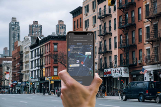
One of the ideas that would change the way step-free routes were addressed was by eliminating going to a different menu and toggling it on. Rather, step free routes are available in the banner that shows different modes of transit such as driving, walking, transit, taxi etc. Step free routes are represented with a wheelchair user icon.

The language in which the directions are written in is also inclusive (for example using the word “trek” rather than “walk).
Addressing Pain Point #2: Elevations and Inclines

One of the pain points earlier regarding elevations and inclines was the visibility of the arrows. In my solution, I made the arrows noticeably bigger and brighter. A color coded incline scale was also added as color can also help the user indicate changes in elevation on a route.

To the right, you can see how changes in elevation are shown with color on the route's pathway.

Any changes in elevation are also present in the route preview.
Addressing Pain Point #3: Reporting Roadblocks

One of the paint points mentioned earlier was that you can only report roadblocks when you choose driving directions. In my solution, users can report roadblocks, regardless of the mode of transit. Roadblocks can heavily impact a wheelchair user and being able to report obstructions helps step-free routes function more efficiently.
Major Takeaways and Next Steps
Ask better questions, such as what methods or devices do you use to help you use transit?
Conduct a user study with the targeted demographic to validate my solution.
If you'd like to try my prototype, look below!